
GRAND RAPIDS, Mich. (May 20, 2014) — The lone active weather day this week may contain some strong to severe thunderstorms, especially along the I-94 corridor late Tuesday into Tuesday night.
A few showers will continue to slide mostly north of I-96 during the first half of the day, with clouds hanging around many parts of central and northern Michigan throughout the daytime. That will likely hold temperatures down a bit and prevent severe weather from developing.
From around I-96 southward, partly sunny skies will allow temperatures to climb into the mid 70s in the afternoon. Storms will develop to the southwest and try to move into southern Lower Michigan late in the day. The best chance of severe storms appears to be south of I-94 in the evening.
The greatest threat from any storms that develop will be damaging wind gusts and large hail. The detailed outlook from the Storm Prediction Center does have the southern half of the FOX 17 viewing area in the “slight risk” category for severe weather, and allows for an enhanced risk of the strongest storms in the southwest corner of the state, as indicated in the images below:
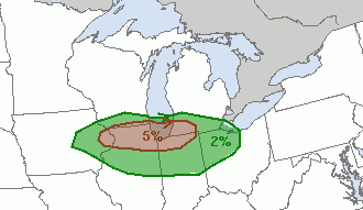
Tornado outlook, 5/20/14

Severe Hail outlook, 5/20/14

Severe Wind Gust outlook 5/20/14
Showers and storms will likely continue in spots overnight into early Wednesday before we dry out once again. Cooler air will eventually arrive, but not until after we manage to push highs into the upper 70s to near 80° Wednesday afternoon.
A dry and pleasant stretch of weather will then take over through Memorial Day weekend — check out the full 7 Day Forecaston the Weather page.
