

GRAND RAPIDS, Mich. — While we slowly pull away from and out of severe weather season, perhaps it’s worth taking a look back at how many severe warnings have been issued by National Weather Service offices around the country to see how West Michigan fares up. Understand that this is in no way an apple to apple comparison since Michigan is being compared to much quieter weather regions and much more active weather regions. The purpose is to just throw the numbers out there to see which areas have experienced the most and least warnings since January first.
We’re lucky…we actually live in a reasonably quiet location weatherwise. We have our fair share of active/severe weather from time to time, but compared to tornado alley, Michigan tends to be on the quiet side. That said, compared to places like California/Washington/Oregon, Michigan is on the far more active side…but at least we don’t sit on a fault line with earthquakes possible and the “big-one” just waiting to happen.
Take a look at the map below. It shows by NWS forecast area the number of tornado warnings issued around the country since January first.
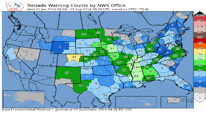
Northeast Colorado takes the cake with 81 tornado warnings issued out of the Boulder office. What the map doesn’t tell us is how many of these actually verified. That is…how many times was a warning issued where a tornado actually touched down? Note the Grand Rapids National Weather Service forecast office only issued one tornado warning this season. We know there was no warning in place July 6th when the Kentwood tornado touched down and did more than four million dollars in damage.
Take a look (below) at the number of severe thunderstorms warnings that were issued thus far this year.

As you can see there are far more severe thunderstorm warnings (typically) issued across the nation rather than tornado warnings. We had 113 issued thus far in 2014 in West Michigan. It’s also important to note that severe thunderstorms can/and often do spawn tornadoes.
Our entire West Michigan area, or Central Warning Forecast Area (CFWA) is made up of two forecast offices. The NWS in Grand Rapids handles most of it, but the NWS in North Webster, Indiana is responsible for our extreme southern counties of Berrien, Cass, St. Joseph, and Branch.
While fabulous fall weather is expected to continue over the next few days, this awesome pattern will come to an abrupt end next week Thursday as rain moves in and we transition in to an upper level pattern on Friday more conducive to cooler, unsettled weather. Get the complete forecast at www.fox17online.com/weather.
