
 WEST MICHIGAN — (Mar. 23, 2014) Cold arctic air moves back into West Michigan Sunday as winter holds on tight. Temperatures will be between 15 to 20 degrees below average throughout the afternoon despite partly cloudy skies and sunshine.
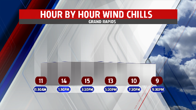
Winds will become northwesterly throughout the afternoon allowing for a slight chance for light lake effect snow showers to develop. Moisture is limited but a few flurries could not be ruled out especially along the Lakeshore. Winds will pick up between 10 to 15 miles per hour dropping feel-like temperatures into the teens for a majority of the day.
Afternoon high temperatures will struggle to reach into the mid to upper 20’s, a far cry from the average high temperature of 47 degrees. Temperatures will gradually start to warm Monday but another shot of cool arctic air moves in by Tuesday dropping temperatures into the upper 20’s for afternoon highs.
Another chance for snow will be possible Monday night and Tuesday morning. Moisture will be limited so snow accumulations will be less than a half inch along and south of the I-94 corridor, with areas north of I-94 likely seeing only a trace of snow. Temperatures gradually warm towards the end of the next work week but still stay below average.
