
WEST MICHIGAN — A strong system will move through the Great Lakes region Thursday and Friday bringing multiple chances for showers and thunderstorms. A few of these storms could be on the strong to severe side as the system moves into West Michigan late Thursday and early Friday.
The Storm Prediction Center has placed parts of West Michigan into a slight risk category Thursday afternoon and evening. Areas along and south of the I-94 corridor are included in the slight risk category meaning that there is a slight chance that storms will develop and become severe into the evening. While the chances for isolated storms to form and become severe are small, there is a better chance for all of West Michigan to see some significant rainfall.

Severe Risk – Friday
As the front moves through after midnight, there will be a continued risk for severe weather early Friday morning. Here is a look at the area under the slight risk for Friday morning.
While the Storm Prediction Center has most of West Michigan under a slight risk, our severe chances are fairly minimal. Clouds and light rain showers in early afternoon Thursday will lessen chances for widespread severe weather Thursday evening.
Our biggest threat as this strong low pressure moves into the region is very heavy rain across most of our areas. This low is tropical in nature meaning that it can be traced back to the remnants of Hurricane Blanca, which struck Cabo San Lucas earlier this week. As the system moves east it will drop lots of gulf moisture. Heavy rains are expected in areas along and north of I-96 through Friday afternoon with rainfall totals possible between 1 and 2 inches.

FutureTrack Rainfall Totals
This inundation of rain could create a flash or urban flooding risk across most of the area Thursday overnight and Friday morning.
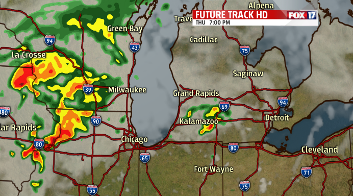
FutureTrack HD Thursday Evening
Strong winds will also be a possibility as the low moves into West Michigan. Thunderstorms that become strong could develop bowing segments, which would create a straight line wind threat. FutureTrack HD, our in-house model times these storms moving in between 4pm and 8pm Thursday.
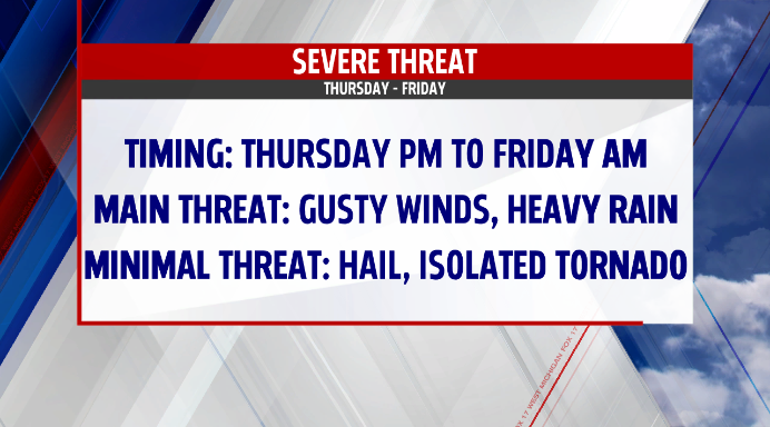
So here is what you can expect over the next 24-hours:
Timing – Thursday early evening through Friday afternoon.
Main Threat – Gusty straight line winds, and heavy rain.
Minimal Threat – Hail and isolated tornadoes.
As always, stay tuned to FOX17 and FOX17online.com for the very latest.
