

WEST MICHIGAN — With a stationary front lingering to our south and west the next day, it will be the focal point for generating a few rounds of showers and thunderstorms, especially on Monday. Some of these storms may be strong to potentially severe with damaging winds as the primary threat.
Our forecast models are showing the possibility of a decaying or dying cluster of storms (mesoscale convective system for you weather geeks) tracking in to West Michigan Monday morning. If we can break out in enough sunshine after the morning storms and destabilize the atmosphere, we’ll likely see a second round in the afternoon/early evening that could be severe. See the convective outlook below from the Storm Prediction Center for Monday.
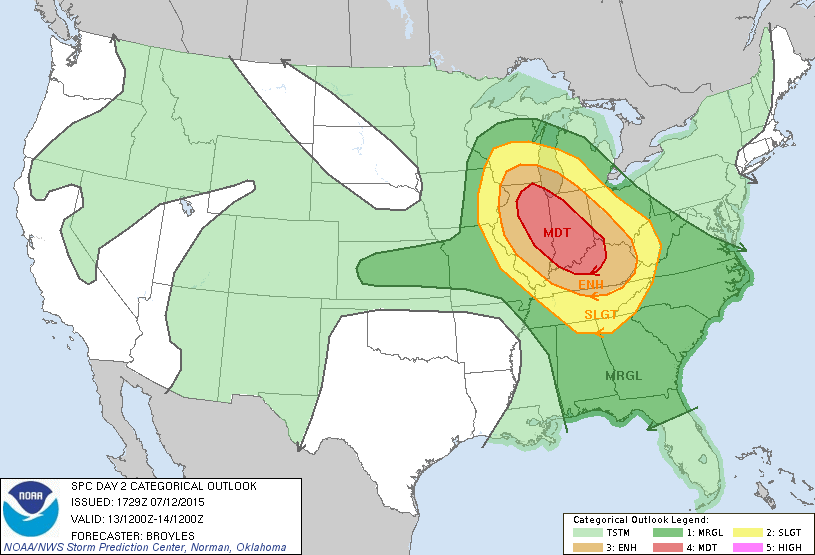
The risk for severe weather actually increases the further south/west from Grand Rapids, with a moderate risk possible outside of our immediate area. Once the low pressure area and frontal system track in to the state on Monday night/Tuesday morning, more showers and storms are likely through about midday Tuesday, before we dry out late in the day. High pressure building in to the region on Wednesday and Thursday will produce dry conditions on those days.
As of Sunday July 12, we’ve gone 670 days with no 90 degree temperature in Grand Rapids. In case you forgot, we never reached 90 last year (2014). That may very well change by the end of this week. A warm front lifting through the state Thursday night/Friday morning may generate a few showers/storms, but once the front lifts through the heat and humidity are expected to build. Dew point temperatures, a measure of moisture in the air, will likely be in the 70s Friday, Saturday, and Sunday with actual air temperatures reaching upper 80s to near 90 degrees. Make your plans now on how you’re going to stay cool when the heat wave hits! Take a look at the forecast model below valid for Friday morning. These are temperatures about 5,000 feet above the surface (850 millibar level for you pilots). Note the deep reds and maroons moving in to Michigan from the south and west.

You can always get the complete forecast at www.fox17online.com/weather.
