


WEST MICHIGAN — There’s been two separate days already this season where we’ve seen some snow flakes and non-accumulating snow showers flying. We’ve actually been experiencing above normal temperatures over the last few weeks. That said, all of you folks waiting with baited breath for accumulating snow may be getting your wish this weekend. A low pressure system is forecast to slide across the Great Lakes Friday night in to Saturday. By itself that wouldn’t be newsworthy, but since colder air will be in place and this could potentially be our first bout with accumulating snow this season, we want to give everyone a “heads up.”
Preliminarily, I see about one to three inches possible, although some forecast models are showing totals could be on the higher order of three to five inches. Regardless, it’s still a bit too early to nail down an exact amount. Most models agree on the general placement of the low, they just differ on snow totals due to snow ratio, precipitation start time, how much cold air is in place, and ground temperature. Suffice to say some snow is likely this weekend…but a snow storm is not likely at this time.
Take a look at the image below. It’s from one of our computer forecast models and is valid for Saturday morning. The purple on the map is accumulated precipitation. Note the “L” (low pressure) over the southern Great Lakes (generating the precipitation).

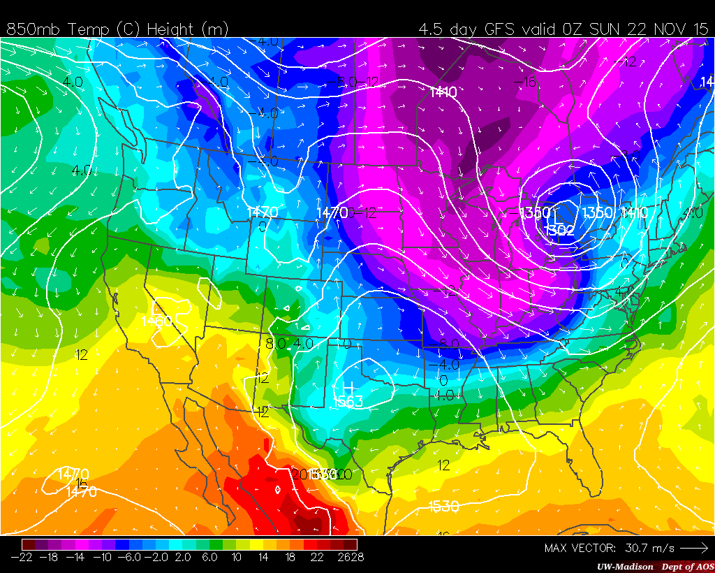
Take a look at the next computer forecast image valid for Saturday evening (below). This is basically a temperature map that shows air masses about 5,000 feet above ground. It’s easy to see the sharply colder tones/colors on the map…so the cold air will certainly be in place. In fact, the coldest air of the season will arrive this weekend. Some of our forecast models are showing temperatures falling throughout the day in to the 20s!
Last year at this time we were dealing with accumulating snow, and two years ago we were dealing with a severe weather outbreak. Michigan was in a moderate risk for severe weather development at the time and at least two tornadoes were reported in/around West Michigan. I remember following along on the National Weather Service damage survey the next day.
The image at the top of this story is from another one of our automated forecast models. It has the capability to show accumulated precipitation (about 3″), type of precipitation (in this case the blue bars are snow), and the time the event starts (around 0z Saturday which is actually Friday evening) and it ends by afternoon Saturday. It’s also important to note this graphic is read from right to left not left to right. Look at the military time stamp on the bottom. Confused? Most weather maps and graphics are referenced to/with UTC or universal time coordinated, also known as Z-time, also know as Greenwich. This BUFKIT profile (as it’s called) is actually a thermodynamic look at the atmosphere and tells us the weather parameters we just mentioned. Long story short…accumulating snow is certainly possible this weekend.
The fact that the ground is still warm and thawed may mitigate some accumulation, but if it comes down hard enough it can/will stick even on the pavement. Make sure to stay up on later forecasts! Get all the information here at www.fox17online.com/weather.
