

WEST MICHIGAN — As we welcome in the month of December this week, don’t look for anything too drastic! Yes an approaching storm system will bring some rain/snow showers Tuesday/Wednesday, but high pressure building back in by the end of the week will quickly return us to sunshine and temperatures at/above normal.
Take a look at the Climate Prediction Center (CPC) outlook for temperatures the next six to ten days below. The map shows the maroon color over the Great Lakes with an 80 percent chance of above normal temps December 5 through the 9th.

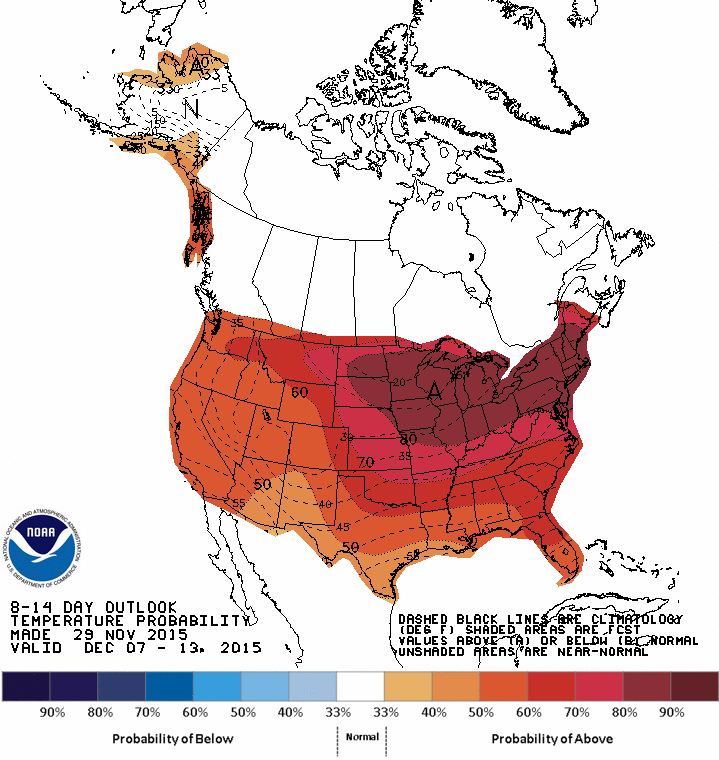
The next map below shows the eight to 14 day temperature outlook December 7 through 13th with another 80 percent chance of above normal temps.
So as the headline reads, we’ll welcome in the new month more like a lamb not lion. These warmer temperatures are the result (in part) of a stronger than normal El Nino. Recall that El Nino are warmer-than-normal ocean waters in the equatorial regions of the Pacific Ocean. Now the question you’re asking…”how does it affect us?”
That warmer ocean water tends to alter the upper level pattern of our jet stream. It forces an upper level high (or ridge) that tends to keep places like the Great Lakes warmer-than-normal and probably a bit drier than normal too. That doesn’t mean we can’t or won’t have a snow storm, it simply means that (on average) our winter tends to be milder and drier.
The image attached to this story shows the huge upper level low pressure system that will affect us Wednesday with cold, breezy, raw, cloudy conditions and a few rain and snow showers. The snapshot is from our forecast model and is valid for Wednesday morning. The arrival of the surface low pressure system will precede the upper low and bring us rain and falling temperatures Monday night and Tuesday. You can get the complete West Michigan forecast at www.fox17online.com/weather.
