


WEST MICHIGAN - After a steamy Wednesday, heat index values may top 100 degrees again today. Cloud cover is a large factor of how hot temperatures will be! The more cloud cover we see, the cooler the temperatures will be. As of now, cloud cover is starting to dissipate in southwest Michigan. This will generate warmer temperatures. Every part of West Michigan is also sitting in extreme humidity at the moment, as well. Strong to severe thunderstorms are expected to develop late this evening and tonight. Below is a breakdown of the anticipated heat, along with the timing and strength of storms.
High Heat and Humidity
Wednesday's heat and humidity was evident in West Michigan with feels-like temperatures over 100 degrees. Below are the heat index values from 5:45 p.m. Wednesday.

Yet another hot day is possible for Thursday. There are clouds currently hindering our heat development, however temperatures could climb into this late afternoon and evening.

Drink plenty of water, limit your time outdoors, and don't forget about your pets! Heat Advisories have been posted for most of the region. Below are the HEAT ADVISORIES and EXCESSIVE HEAT WARNINGS posted for today.

Here's a look at the heat index chart from the National Weather Service pairing the temperatures and humidity making how our temperatures will feel.

Strength of Storms This Week
Dew point temperatures, a measure of moisture in the air, will be in the 70s again today. Wednesday's dew point temperature soared to 79 degrees. With all that moisture in the atmosphere, that means heavy rain will be possible with any of the storms that do form.
Rounds of thunderstorms will be possible after 7 p.m. Thursday. The entire area has been placed under an outlook for severe storms today. Parts of West Michigan, mainly southeast of Grand Rapids, have been upgraded to an ENHANCED RISK of severe storms. The rest of the region falls under a SLIGHT RISK for severe storms.

All-in-all, our atmosphere is very complex going into tonight. There are parts of the atmosphere that are "checking boxes" for severe weather development. That includes the amount of moisture in the air and the amount of instability. Thunderstorms gain fuel from both of those things! The parts that are uncertain is how strong our passing cold front will be (or lift) and just how high temperatures will rise into this afternoon. The hotter our temperatures rise, the more instability that we could see.
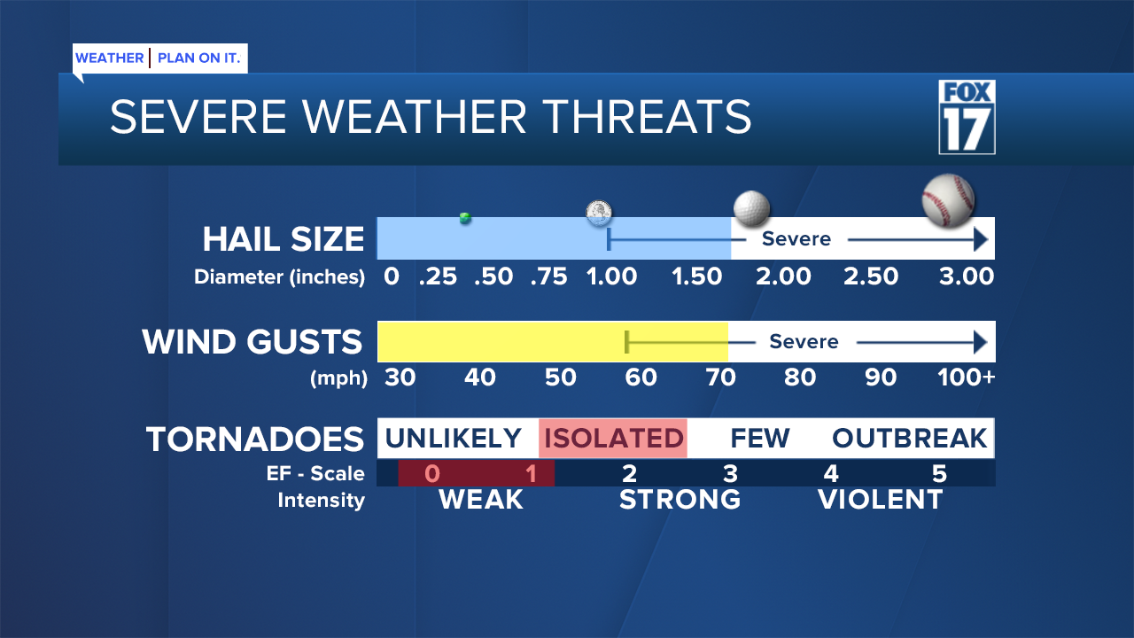
In complete transparency, there are quite a few elements of tonight's forecast that remain uncertain. What we DO know is that if a severe thunderstorm does develop, it could produce hail over 1" in diameter and wind gusts up to 70 mph. Heavy rain will be likely, leading to localized flooding. An isolated tornado can't be ruled out, either.
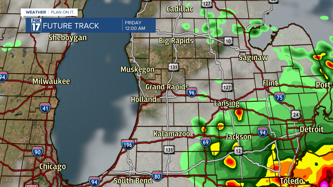
The latest forecast models are beginning to line up, showing development of thunderstorms after 7 p.m. Thursday.

Storms will travel from the northwest towards the southeast, eventually reaching I-96 around 9 p.m. Thursday.

The region closer to I-94, including Kalamazoo and Battle Creek, could see storms after 10 p.m. Thursday.

Our latest models show the threat of severe weather ending by midnight.
Stay tuned with FOX 17 for updates on the timing and strength of storms. You can always download the free FOX 17 Weather App for immediate severe weather alerts. If you have outdoor plans on Thursday, maybe a high school football game, have several ways of receiving severe weather alerts!