WEST MICHIGAN - Strong, damaging straight line winds blasted through portions of southern Lower Michigan on Thursday evening. Things initially started in the late afternoon with a SEVERE THUNDERSTORM WATCH being issued for all of central and southern lower Michigan.
By 7:30 P.M., strong to severe thunderstorms were beginning to develop from Fremont to Muskegon. These storms moved south and east into western Montcalm County and northern Kent County. Additional severe thunderstorm warnings were issued and the line intensified with extensive lightning, torrential rainfall, and cells producing wind gusts or 65 to 75 mph. See image below. It shows velocity, or wind data with green colors moving toward the radar site and red colors moving away. The bright pink shows the strongest wind speeds of 70 to 80 mph as indicated by radar. The red lines indicate the areas where the most widespread damage occurred.

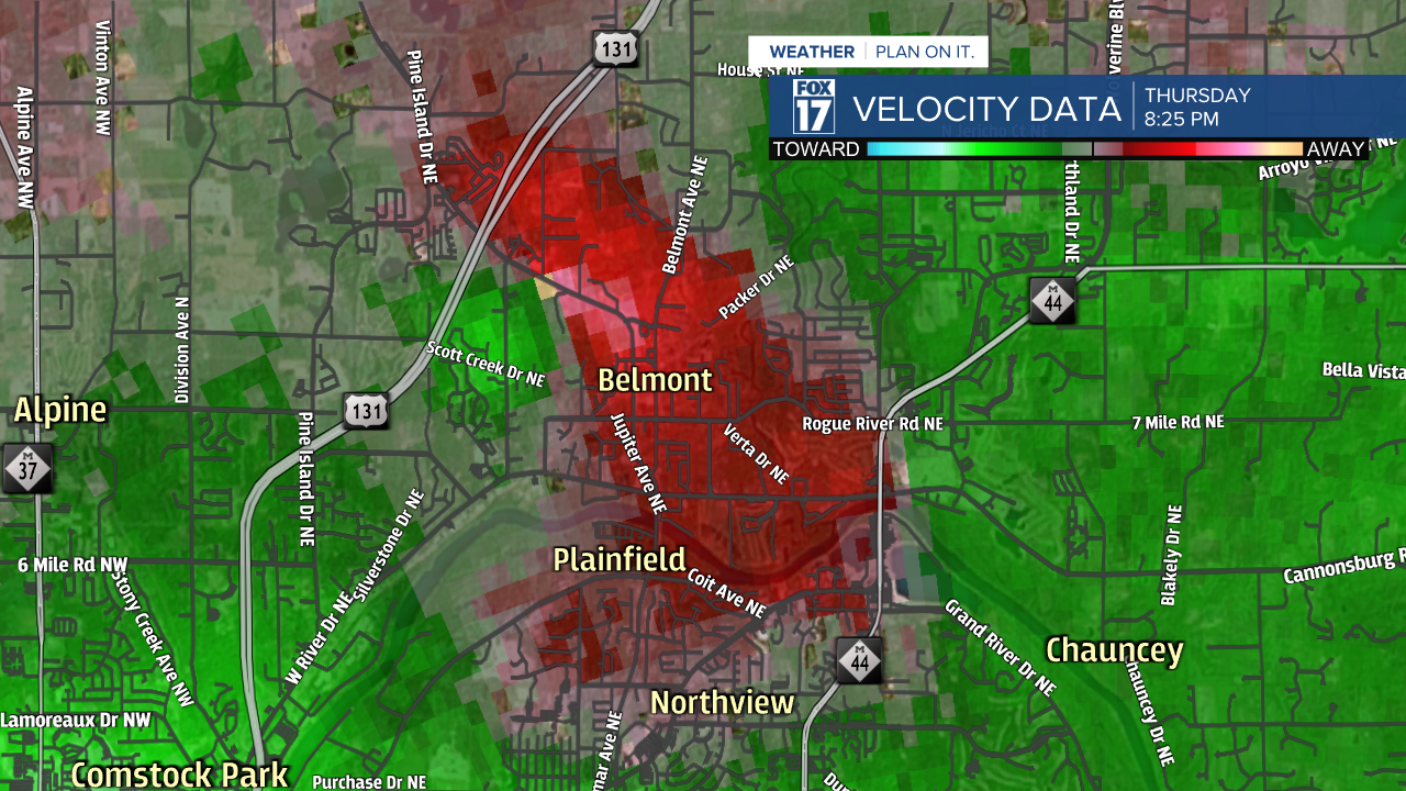
A TORNADO WARNING was issued for a time in Kent County with some rotation detected around the Plainfield Township and Belmont areas. The image below is velocity data at 8:25 P.M. zoomed in to almost street level around Belmont. The bright red area next to the bright green area indicates strong rotation, gate to gate shear, and the possibility of a tornado touching down. Our wind velocity data showed 43 mph inbound winds, and 46 mph outbound winds. Preliminary information indicates that a high EFO or lower end EF1 tornado may have occurred, as the defined tornado signature on radar was prevalent.

The photo below shows a house in Belmont sustaining significant damage from either a brief tornado or straight line winds. The National Weather Service will likely conduct a survey on Friday to determine the type of damage that occurred.

Once these storms pushed through Kent County, they continued in full strength dropping south and east into Ionia County, northern Eaton County, and the Lansing area. Wind speeds of 70 to 80 mph or more occurred ripping off roofs, downing trees, and leaving hundreds of thousands without power statewide.
Below is a radar image valid at 9 P.M.. You can see the extensive lightning and torrential rainfall and the well defined line of severe thunderstorms.

As of the writing of this story at 1 A.M. Friday morning, more than 388,000 people are without power. See image below. Suffice to say it will likely be a few days before all power is restored.

Make sure to stay tuned to FOX 17 News as more damage reports come in, surveys are conducted, and additional information is gathered by our crews.


