WEST MICHIGAN — The Storm Prediction Center has released their updated storm outlook for today and tonight. After a round of strong to severe thunderstorms and a tornado warning Monday evening, the threat of severe weather extends into this evening and early overnight past midnight. It will shift to southeast Lower Michigan on Wednesday.
What's the severe storm threat for today?
Our entire area falls under a SLIGHT RISK or level 2 out of 5 for severe thunderstorms. Damaging straight line winds are the primary threat, with a non-zero but very low tornado threat.
The threat of severe weather will extend across most of northern and Lower Michigan today as well. The track and strength of this system will produce a higher risk of severe weather across Wisconsin, Illinois, Iowa, and Missouri. Models have pushed the center of this storm slightly West, meaning we should miss the worst of the event, but that does not mean tornadoes aren't possible. It's also good that the storm system tracks across our state in the overnight hours during negative heating, and not during prime daytime heating. That may help mitigate (to some degree) our severe weather threat.

Take a look at the tornado threat percentages with this system below. Our tornado is not zero, but it is low in West Michigan.

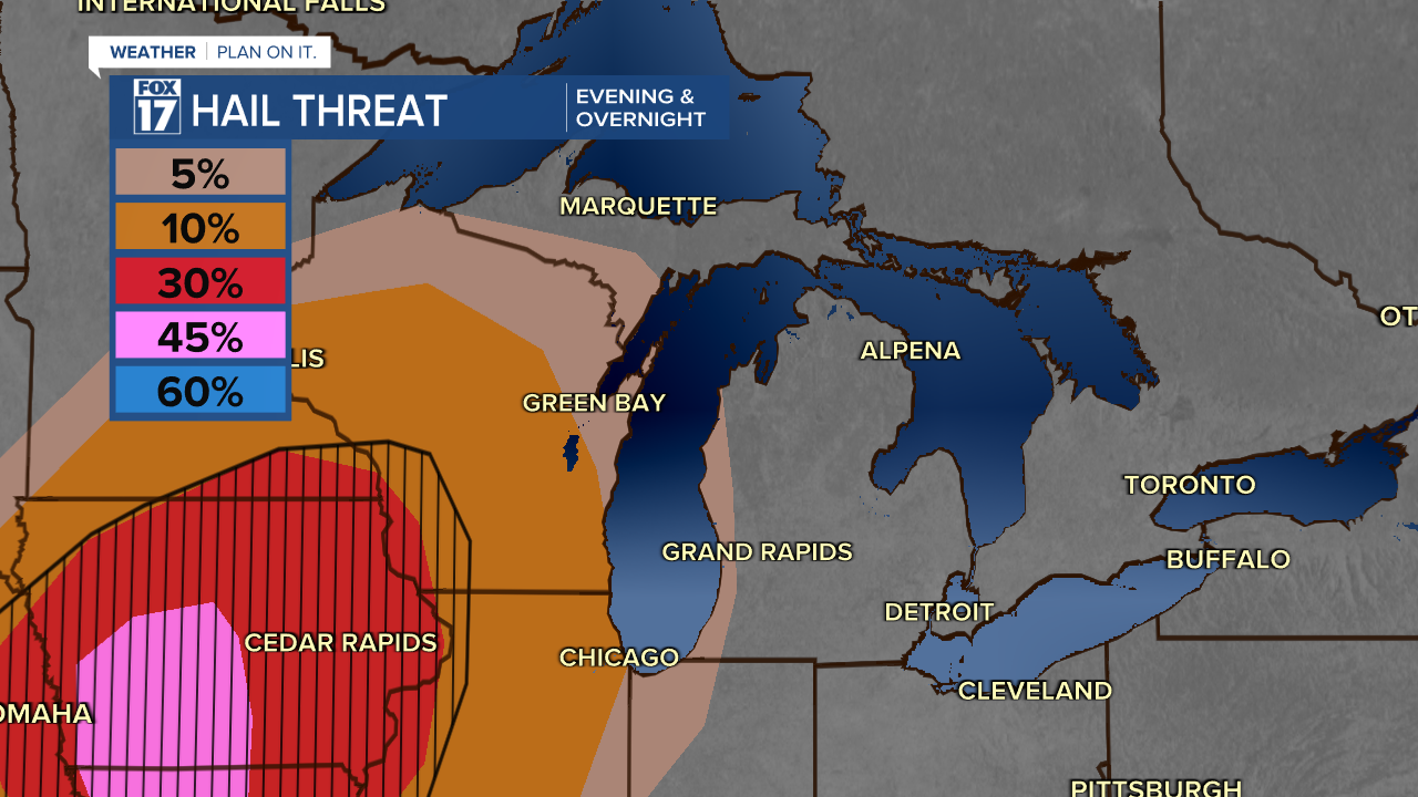
Take a look at the hail threat percentages below. Low in West Michigan, but not zero.

The greatest potential for strong to severe thunderstorms will be in this after 11 P.M. and northwest of Grand Rapids. Our severe weather potential seems to be lesser than northern Lower Michigan as of 8 P.M..

We are trending quite dry, but any storm that does develop will still look to pack a punch with wind, 60 mph or stronger is possible.

The risk of severe weather is lower because the cold front moving behind these storms has weakened, and won't allow for a lot of mixing in the atmosphere for storms to fire off in West Michigan.

In order for a thunderstorm to be considered severe, it needs to have wind gusts at least 58 mph and/or hail at least one inch in diameter. For more information about what makes a thunderstorm severe, click here. Here are the severe weather threats below for this evening and overnight. 70 to 75 mph wind gusts, golf ball size hail, and an isolated tornado EF0, EF1, EF2 can't be ruled out.

Stay alert with the FOX 17 Weather Team for updates ahead of next week's weather. For the latest details on the weather in West Michigan, head to the FOX 17 Weather page.
Follow FOX 17: Facebook - X (formerly Twitter) - Instagram - YouTube


