WEST MICHIGAN — Although we just kicked a snow system out after it dropped a widespread 3-6" of snow, get ready for another one! Another big low pressure system coming out of the western U.S. will be moving through West Michigan starting late tomorrow evening, with steady snow expected through much of Saturday. Travel will likely be impacted during the day Saturday.
See our projected snow totals through Saturday evening below.
![DMA Hand Drawn Snow Totals2.png](https://ewscripps.brightspotcdn.com/dims4/default/f123b7f/2147483647/strip/true/crop/1280x720+0+0/resize/1280x720!/quality/90/?url=http%3A%2F%2Fewscripps-brightspot.s3.amazonaws.com%2F72%2Faa%2F6615154247e692f4e9580bef41af%2Fdma-hand-drawn-snow-totals2.png)
THE SETUP:
A low pressure system will organize in the Plains today, ejecting into the Great Lakes. West Michigan will stay dry during the day, but by late evening the snow will be starting to spread in from the west.
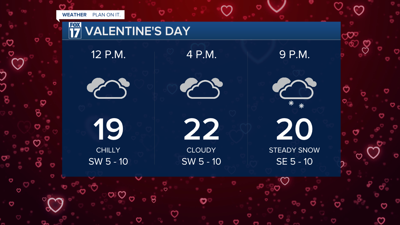
![Valentines Day PLANNER.png](https://ewscripps.brightspotcdn.com/dims4/default/493b2a0/2147483647/strip/true/crop/1280x720+0+0/resize/1280x720!/quality/90/?url=http%3A%2F%2Fewscripps-brightspot.s3.amazonaws.com%2F34%2F26%2Fe499182f445f8212db5c510fdb7d%2Fvalentines-day-planner.png)
TIMING:
See the forecast model timeline below. Note that there are several parts to this forecast. Part one occurs Friday night into Saturday. Part two is the chance for steady to moderate snow Saturday night into Sunday as a low pressure system tracks into the Ohio Valley. Part three occurs Sunday night into Monday with lake effect snow and Arctic air arriving.
![6Z GRAF 12KM Midwest6AMFRI.png](https://ewscripps.brightspotcdn.com/dims4/default/0e69c51/2147483647/strip/true/crop/1280x720+0+0/resize/1280x720!/quality/90/?url=http%3A%2F%2Fewscripps-brightspot.s3.amazonaws.com%2F47%2F3e%2Ffaceebc54f2fb9a7ebfde99b6f01%2F6z-graf-12km-midwest6amfri.png)
![6Z GRAF 12KM Midwest6AMSAT.png](https://ewscripps.brightspotcdn.com/dims4/default/ca02733/2147483647/strip/true/crop/1280x720+0+0/resize/1280x720!/quality/90/?url=http%3A%2F%2Fewscripps-brightspot.s3.amazonaws.com%2F14%2Fb4%2F721d8bd34036898c22cd69f29c31%2F6z-graf-12km-midwest6amsat.png)
![6Z GRAF 12KM Midwest6PMSAT.png](https://ewscripps.brightspotcdn.com/dims4/default/08b7512/2147483647/strip/true/crop/1280x720+0+0/resize/1280x720!/quality/90/?url=http%3A%2F%2Fewscripps-brightspot.s3.amazonaws.com%2Fda%2F9a%2F07cbd155474498e08f15bd273625%2F6z-graf-12km-midwest6pmsat.png)
![6Z GRAF 12KM Midwest6AMSUN.png](https://ewscripps.brightspotcdn.com/dims4/default/a1711fb/2147483647/strip/true/crop/1280x720+0+0/resize/1280x720!/quality/90/?url=http%3A%2F%2Fewscripps-brightspot.s3.amazonaws.com%2F5f%2Fb3%2F85d5969f4a78a8cc5a58086b55cb%2F6z-graf-12km-midwest6amsun.png)
![6Z GRAF 12KM Midwest6PMSUN.png](https://ewscripps.brightspotcdn.com/dims4/default/d1d04a6/2147483647/strip/true/crop/1280x720+0+0/resize/1280x720!/quality/90/?url=http%3A%2F%2Fewscripps-brightspot.s3.amazonaws.com%2F60%2Fe9%2Fdb899e3345b380349845e7e04577%2F6z-graf-12km-midwest6pmsun.png)
Difficult driving conditions are expected through the weekend. Saturday will be the warmest day of the week with highs right around freezing. This would lead to wet, heavy snow that will melt and compact some, which could affect overall totals.
For the latest details on the weather in West Michigan, head to the FOX 17 Weather page.
Follow FOX 17: Facebook - X (formerly Twitter) - Instagram - YouTube